The IPDC has modern equipments for the surveying and processing of
field information (points, lines, polygons) of known international marks
those which allow obtaining measurements of high quality using the most
modern technologies in the market. Among these equipments they are:
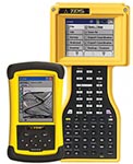
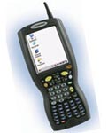
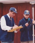
PDA Equipments For Field Surveying
Equipments that integrate the GPS technology with portable computer
technology, allow the integration in real time of geomatic data with
alphanumeric information collected in field. These tools allow the surveying
of cadastral data in a quick and precise way, also allow, discharging
the information in an automatic way to a server of data.
These teams allow collecting data in field and they can be used in
the following fields:
  |
- Urban and rural cadaster
- Road characterization
- Determination of limits and boundaries
- Environmental evaluation
- Commercial verification
- Inventory of nets for communications, water and energy
- Geomarketing applications
- Agriculture of precision
|
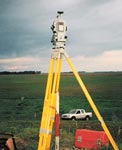
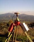
DGPS EQUIPMENTS
- GPS MARK PENTAX (Japan), Model: 9500D.
Double frequency, 12 Channels
Reach among receivers: Up to 500 Km. Advisable 100Km.
Precision in static way + (5mm+1ppm x D)min (MILLIMETRIC).
IT INCLUDES:
02 receivers (Bases and Rover)
02 batteries for equipment, offering autonomy of 10 hours approximately
with batteries loaded to the maximum.
02 operators of GPS
Post - data processing and reports, according to that required
by the client. Datum WGS 84 / ITRF 94; Ellipsoid: WGS84 / GRS
80, Model Geoidal: EGM96
- GPS NIKON / Novatel OUTRIDER RTK.
Positioning in real time with the exclusive technology of Novatel
Narrow Correlator Precision: 2 cm. In real time
Post-processing: 0.5 cm
IT INCLUDES:
01 Rotational adapter
01 cable for antenna 5m.
01 cable for antenna 10m.
01 software Post-processing Softsurv
01 Software adjustment-nets
|
01 disconnect adapter
01 disconnect adapter
01 kit for cane of Backpack
01 Kit for cane of precision
01cane with support for collector.
01 base of radio equipment
01 backpack for radio equipment
02 Data gatherers
02 sign receivers L1/L2
02 Air Antenna L1/L2 02 Batteries
02 loaders 02 Backpacks
02 cables of Energy
02 cables from the collector to the controller.
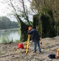
- GPS CINEMATIC IN REAL TIME. RTK
Continuous surveying and restating phase
Registration of phase in movement
Mayor precisions 1-5 cm.
DAB provides more bandwidth
More specific Field of applications
DAB application. Subtask 7C
- DIFFERENTIAL GPS ASHTECH PROMARK
The team includes the following:
Two receivers
Two external antennas
Two extensions of vertical antenna
Two tapes of Ashtech measurements
Two connection cables for the vertical antenna
The clip to fix to the tripod
|
Total Stations and Theodolites:

 |
- TOTAL STATION NIKON DTM 420
Precision: 1"
Distance: 3,500 m.
It allows registering up to: 2000 points
Screen Both Sides
IT INCLUDES:
02 batteries
01 loader of Batteries
02 Triple and simple prism supports with/04 prisms 02 Telescopic
canes
01 Cable RS 232
01 software TRANSIT.
- ELECTRONIC THEODOLITE PENTAX SERIES ETH
With incremental codifier PENTAX system that assures precision
in results in the measurement of angles. The angle can be transmitted
to a PENTAX telemeter or to a data gatherer through the interface
RS-232C (ETH-105A)
|
EQUIPMENT OF POST PROCESSING AND SUPPORT
The IPDC possesses a wide technological infrastructure installed in
its offices integrating a wide defined net mainly for the following
hardware:
- Servers
o Cadastral database servers
o Graphic database servers
o Backup servers
o Internet server
o Firewall server
o Intranet server
- Computers
o Net with more than 25 PCS of the latest generation
- Notebooks
o Notebook Dell PIV 512 MB RAM
o Notebook Dell PIV 256 MB RAM
o Notebook Toshiba Centrino 1.8GHz
|
-
Plotters
o HP Desinjet 4000
o HP Desinjet500
-
Printers
o Epson Stylus C48
o Epson Stylus D88
o Epson Aculaser C1100
o HP Laserjet 1020
o HP Laserjet 1022
-
Projectors
o Projector range 2400 Lumens
|